About All Tours Hiking ToursFull Day ToursFrom El Calafate ToursFrom Puerto NatalesFrom Punta Arenas ToursPrivate ToursGrey Glacier Tours Directions Hours & Fees
Find Tours 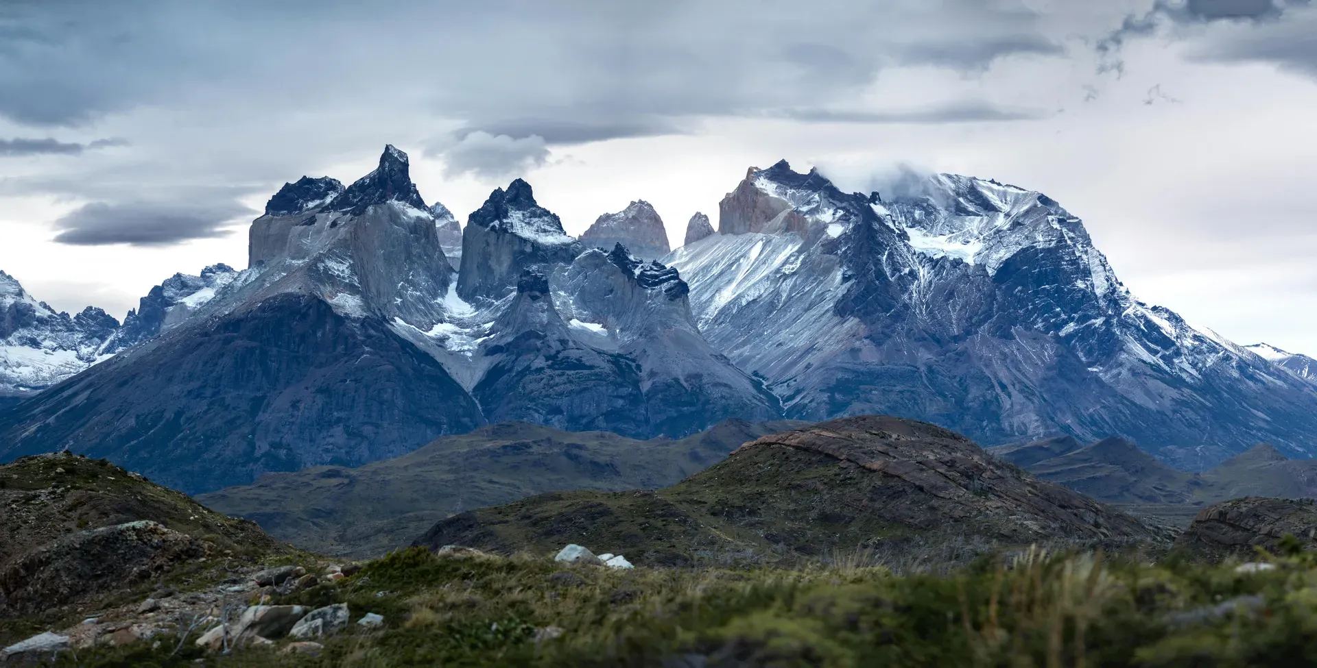
Torres del Paine spans 227,298 hectares of jagged granite peaks, glacial lakes, and subpolar forests in southern Chilean Patagonia. The park sits 112 kilometers north of Puerto Natales and anchors the edge of the massive Southern Patagonia Ice Field.
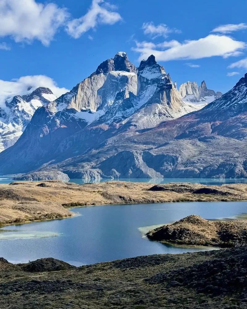
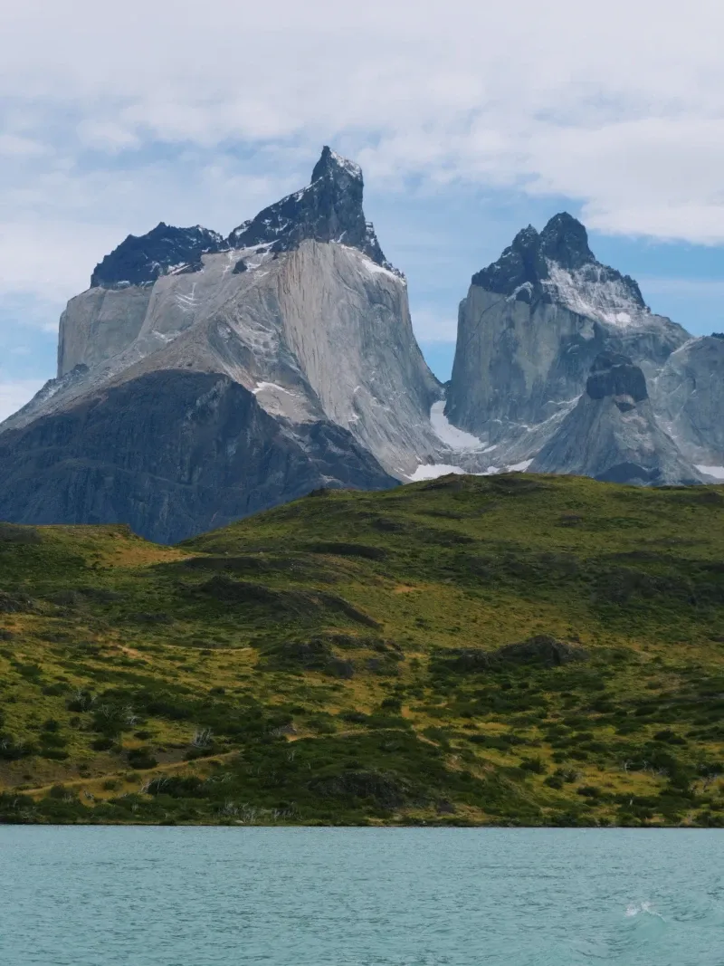
Three vertical granite towers rise 2,500 meters above the Patagonian steppe, giving Torres del Paine its name. The park covers 227,298 hectares of southern Chile, sitting 112 kilometers north of Puerto Natales. Glacial meltwater fills lakes like Pehoé, Nordenskjöld, and Sarmiento, turning them opaque turquoise from suspended rock flour. Ice fields stretch across the western boundary, calving blue icebergs directly into Grey Lake. Wind regularly exceeds 100 kilometers per hour, stripping warmth from hikers even in mid-summer.
Four distinct ecological zones collide within the park boundaries. The Andean Desert dominates the high altitudes above 1,500 meters, giving way to Magellanic subpolar forests of lenga and coigüe trees. Lower elevations transition into Pre-Andean shrubland before flattening out into the vast Patagonian steppe. Guanacos graze near the eastern entrance at Laguna Azul, while Andean condors ride the thermal currents above the French Valley. Hikers navigate this terrain via two primary routes. The W Trek covers 71 kilometers over five days, hitting the major viewpoints. The O Circuit extends this into an eight-to-ten-day loop around the entire massif, crossing the 1,200-meter John Gardner Pass.
Weather dictates every movement on these trails. Winter temperatures drop to -7°C between May and September, reducing daylight to eight hours and forcing mandatory guide requirements. Summer brings 17 hours of sunlight but also crowds of up to 150,000 annual visitors. High winds can ground boat crossings across Pehoé Lake without warning. Check the CONAF website daily for trail closures before leaving your campsite.
Glacial ice retreated from the Magellan Region roughly 14,000 years ago, exposing the jagged Paine Massif. Indigenous Aonikenk nomadic hunters arrived shortly after, tracking guanaco herds across the steppe. They navigated by the massive granite pillars, viewing them as stone guardians rather than climbing objectives. European explorers did not document the formations until 1880, when British traveler Lady Florence Dixie rode through the area. She named the three central peaks "Cleopatra's Needles" in her published journals, drawing the first international attention to the region.
Early 20th-century settlers carved the surrounding land into massive sheep estancias. Overgrazing and deliberate forest fires cleared large tracts of native lenga trees, fundamentally altering the ecosystem. The Chilean government intervened on May 13, 1959, establishing Parque Nacional de Turismo Lago Grey to halt the agricultural expansion. Officials renamed the protected area Torres del Paine in 1970. During this era, international mountaineers began targeting the unclimbed vertical faces. Italian climber Guido Monzino secured the first successful ascent of the North Tower in 1957, utilizing heavy expedition tactics and fixed ropes.
Recreational trekking took shape in 1976 when John Gardner pioneered the full O-Circuit trail. He connected the northern valleys with the Grey Glacier overlook, creating a continuous loop around the massif. Infrastructure followed slowly as the park grew from a collection of reclaimed private haciendas into a 700-square-mile protected zone. UNESCO designated it a Biosphere Reserve in 1978, recognizing the unique convergence of four ecological zones and the need for global conservation efforts. Estancia Cerro Paine remains the only private land inside the park, operating as a base for hikers attempting the Base Torres trail.
Modern management focuses heavily on fire prevention and crowd control. Devastating human-caused wildfires burned tens of thousands of hectares in 1985, 2005, and 2011. The 2011 fire alone destroyed 17,000 hectares after a tourist burned toilet paper in high winds, leaving visible scars of charred trees near Lake Pehoé. Law 20,653 now strictly prohibits unauthorized heat sources, including camp stoves outside designated areas. Violators face immediate expulsion from the country, three years in prison, or fines reaching 2,000,000 CLP.
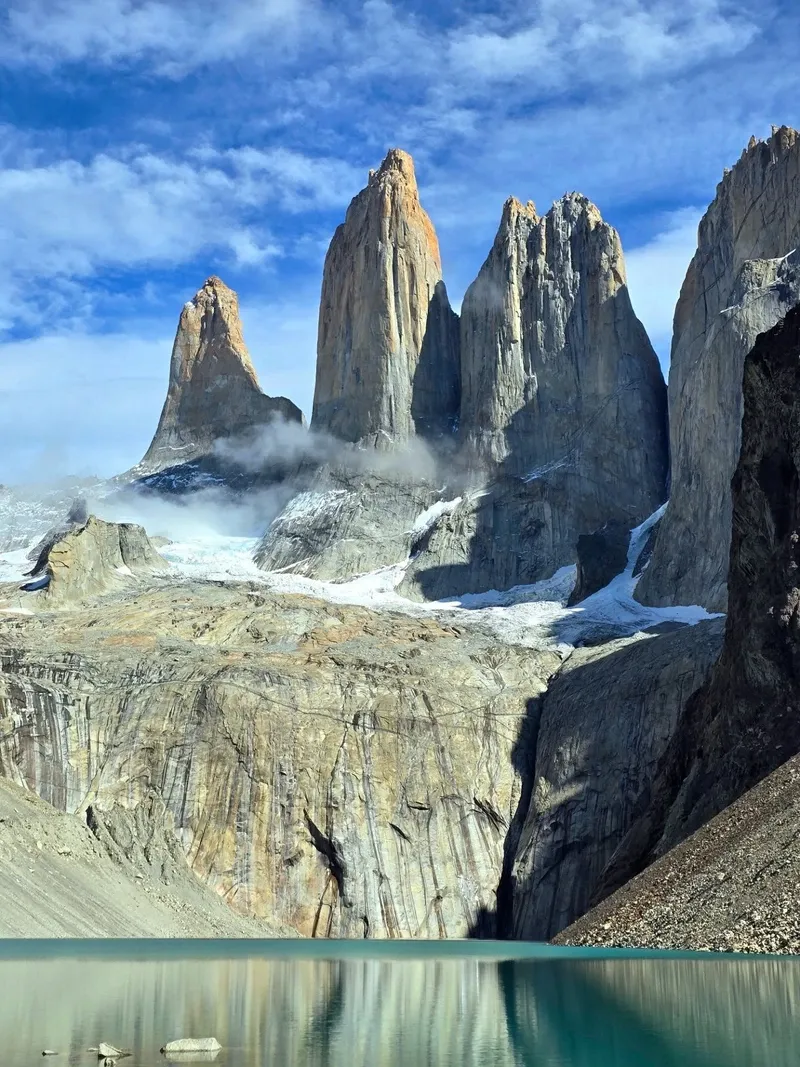
The Paine Massif operates as an independent geological formation, completely separate from the Andes Mountains. Magma intruded into the earth's crust 12 million years ago, cooling slowly to form a massive block of pale granite. Tectonic forces pushed this block upward through older, dark sedimentary rock. Millions of years of glacial erosion stripped away the softer outer layers, exposing the three sharp towers—Torre d'Agostini, Torre Central, and Torre Monzino. The Cuernos del Paine still retain caps of the dark sedimentary rock, creating a sharp chromatic contrast against the gray granite bases. The highest point, Cerro Paine Grande, reaches 2,884 meters and remains heavily glaciated year-round.
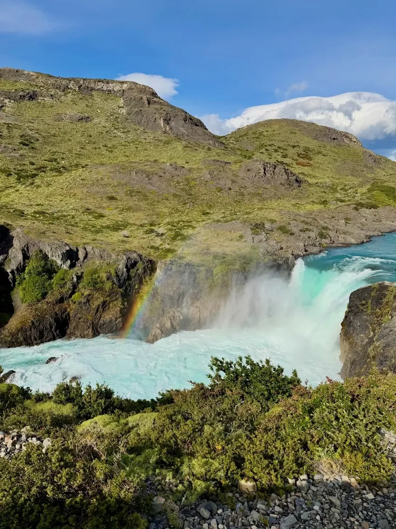
Water shapes the lower elevations with equal force. The Southern Patagonia Ice Field covers 6,000 square miles to the west, feeding dozens of glaciers. Grey Glacier measures six kilometers wide and 30 meters high at its face, dropping massive blocks of blue ice into Grey Lake. Salto Grande waterfall channels the overflow from Lake Nordenskjöld into Lake Pehoé. The spray hits the viewing platform 20 meters away as turquoise water funnels through a narrow rock chute at immense pressure. In the French Valley, hikers cross suspension bridges over glacial rivers, surrounded by 360-degree views of hanging glaciers that frequently release avalanches echoing through the basin.
Vegetation adapts to constant wind and shallow soil. The Magellanic subpolar forest relies on the deep root systems of lenga and coigüe trees to withstand gusts exceeding 100 kilometers per hour. Higher up the Ascencio Valley, the tree line abruptly ends, leaving only lichen and hardy alpine shrubs clinging to the moraine. Wildlife thrives in specific pockets of these zones. Pumas maintain a high population density in the eastern sector near Sarmiento Lake, hunting the abundant guanaco herds. Hikers attempting the Base Torres viewpoint must navigate the final kilometer over loose, unstable boulders deposited by retreating glaciers.
The indigenous Aonikenk people structured their seasonal migrations around the visibility of the Paine Massif. They believed the granite peaks were sacred stone guardians housing powerful nature spirits. These entities protected the land from harm and controlled the fierce Patagonian winds. The name "Paine" originates from the Aonikenk word for "blue," referencing how the towers appear against the sky on clear days. This deep mythological connection shaped how early inhabitants interacted with the landscape, treating the high valleys as restricted zones and remaining primarily on the lower steppes.
Local gaucho culture remains visible on the park's borders. Descendants of the original estancia workers still run sheep and cattle on neighboring private lands. They navigate the steppe on horseback, wearing traditional wool boinas and heavy canvas bombachas to block the wind. Many of these riders now work as guides or packhorse operators, transporting supplies to remote refugios along the W-Trek. Their knowledge of the terrain and weather patterns proves essential for logistical operations during the harsh winter months, often sharing traditional yerba mate with trekkers at the end of a long riding day.
Global recognition shifted the region's economic focus from livestock to conservation. Over five million people voted Torres del Paine the Eighth Wonder of the World in a 2013 virtual poll. National Geographic ranked it the fifth most beautiful place on the planet. This influx of attention forced local communities in Puerto Natales to adapt rapidly, transforming a quiet fishing and ranching outpost into a major logistical hub filled with gear rental shops, boutique hotels, and daily bus fleets.
Drone use is completely banned throughout the 227,298-hectare park to protect wildlife and maintain silence.
The Southern Patagonia Ice Field bordering the park holds the world's second-largest contiguous extrapolar ice field.
Wind speeds in the park frequently exceed 100 kilometers per hour, strong enough to knock hikers off their feet.
Guanacos, wild relatives of the llama, roam the eastern steppe and can run up to 56 kilometers per hour.
Park rangers mandate a strict three-layer clothing system for all hikers due to rapid, unpredictable temperature drops.
Visitors must secure confirmed reservations for all campsites and refugios before arriving at the entrance gates.
Andean condors nesting in the park's cliffs possess a wingspan of up to 3.3 meters, making them the largest flying land birds.
Public buses depart daily from Puerto Natales, taking two hours to cover the 112-kilometer distance to the park entrances. Travelers flying in usually land at Punta Arenas, which requires an additional three-and-a-half-hour drive to reach Puerto Natales. Book bus tickets online weeks in advance during the summer season.
Foreign adults pay 34,000 CLP for stays up to three days, and 48,500 CLP for longer visits. Chilean citizens pay a reduced rate of 9,900 CLP for short stays. Entry is completely free for children under 12 and people with disabilities.
Independent hiking is permitted during the summer months from October to April. Winter treks between May and August require a certified, specialized guide due to freezing temperatures and limited daylight. You must also show proof of campsite reservations regardless of the season.
Summer temperatures average between 10°C and 18°C, with up to 17 hours of daylight. Winter brings temperatures as low as -7°C and reduces daylight to just eight hours. High winds are constant year-round and can drastically lower the perceived temperature.
No. Drone flights are strictly prohibited everywhere inside the park boundaries. Park rangers enforce this rule to prevent disturbances to the local wildlife and preserve the natural soundscape.
Chilean Law 20,653 strictly bans unauthorized fires and heat sources, including wood or charcoal. Violators face fines up to 2,000,000 CLP, three years in prison, or immediate expulsion from the country. Cook only in designated refugio areas using approved camping stoves.
The standard W Trek takes four to five days to complete, covering approximately 71 kilometers. The longer O Circuit requires eight to ten days and circles the entire Paine Massif. Both routes require booking campsites up to six months in advance.
The Serrano Visitor Center features wheelchair ramps and accessible facilities. The pathway around Grey Lake remains mostly flat and accommodates mobility scooters. Specialized tour operators offer adapted vans to reach viewpoints like Lake Pehoé without extensive walking.
October through April offers the warmest weather and longest daylight hours for trekking. November and March provide a balance of decent weather and slightly smaller crowds than the peak months of December through February.
The park supports large herds of guanacos and rheas on the eastern Patagonian steppe. Pumas hunt these herds, though they remain elusive and are mostly spotted at dawn or dusk. Andean condors frequently circle the thermal drafts above the French Valley.
Browse verified tours with free cancellation and instant confirmation.
Find Tours